31 July 2023

Fine aggregate/Sand

Aggregate is the granular material used to produce concrete or mortar. Sand is a form of silica (quartz) and may be of argillaceous, siliceous or calcareous according to its composition. Natural sands are formed from weathering of rocks (mainly quartzite) and are of various size or grades depending on the intensity of weathering. The sand grains may be of sharp, angular or rounded. Aggregates passing through 4.75mm sieve and retained on 75micron sieve is termed as fine aggregate.

Fine aggregate sand is important ingredient of mortar and cement concrete. Sand particles consist of small grains of silica. It is formed by decomposition of sand stone due to various effects of weather. River sand is widely used as fine aggregate. Fine aggregates are classified as follows: 

  1. Source of Origin 
  2. Grain Size 
  3. Composition

I) Classification according to Sources of Origin

Sand particles consist of small grains of silica (Si02). It is formed by the decomposition of sand stones due to various effects of weather. The following are the natural sources of sand.

1) Pit Sand

This sand is found as deposits in soil and it is obtained by forming pits to a depth of about 1m to 2m from ground level. Pit sand consists of sharp angular grains, which are free from salts for making mortar. Clean pit sand free from organic matter and clay should be used.

Pit Sand

2) River Sand

This sand is obtained from beds of rivers. River sand consists of fine rounded grains. Colour of river sand is almost white. As the river sand is usually available in clean condition, it is widely used for all purposes.

River Sand

3) Sea Sand

This sand is obtained from sea shores. Sea sand consists of rounded grains in light brown colour. Sea sand consists of salts which attract the moisture from the atmosphere and causes dampness, efflorescence and disintegration of work. Due to all such reasons, sea sand is not recommendable for engineering works. However be used as a local material after being thoroughly washed to remove the salts.

Sea Sand

The natural product which is obtained as river sand & pit sand is called sand.

II) Classification Fine Aggregate According to Grain Size

Fine aggregate 

Size variation (mm)

Coarse Sand

0.5 – 2.0

Medium sand

0.25 –  0.5

Fine sand

0.060 – 0.25

Silt

0.0020 – 0.06

Clay

<0.002


III) Classification Fine Aggregate According to Composition 

1) Clean Sand 

These are well-graded sand containing quartz particles in a wide range of grain sizes. 

2) Silty Sand 

These are poorly graded, having a considerable proportion of silt and other non-plastic fines. 

3) Clayey Sand 

There is poorly graded sand that has a prominent clay fraction and also plastic fines.

Requirement of good sand

  1. It should be hard
  2. It should be chemically inert
  3. It should be free from salts
  4. It should free from organic matters
  5. It should be well graded

Uses of sand

  1. It is used in mortar
  2. It is used in concrete
  3. It is used for the filling the gaps between the building blocks
  4. It is used as binding materials in the form of paste
  5. It prevents the shrinkage of cementing materials.

Alternatives to river sand

Sand is a vital ingredient in making two most used construction materials viz. cement concrete and mortar. Traditionally River sand, which is formed by natural weathering of rocks over many years, is preferred as fine aggregate. The economic development fuelling the growth of infrastructure and housing generates huge demand for building materials like sand. The indiscriminate mining of sand from riverbeds is posing a serious threat to environment such as erosion of riverbed and banks, triggering landslides, loss of vegetation on the bank of rivers, lowering the ground water table etc. Demand for sand is increasing day by day and at the same time mining threats cannot be ignored. Hence, sand mining from riverbeds is being restricted or banned by the authorities like National Green Tribunal, State Environmental Impact Assessment Authority and Pollution Control Board. Hence it is necessary to find and use the alternative for river sand.

Some of the Alternatives to River sand are:
  • Manufactured sand
  • Processed quarry dust
  • Processed crushed rock fines
  • Offshore sand
  • Processed glass
  • Aluminum saw mill waste
  • Granite fines slurry
  • Washed soil (filtered sand)
  • Fly ash (bottom ash/ pond ash)
  • Slag sand
  • Copper slag sand
  • Construction Demolition waste

Manufactured Sand (M-Sand)

Manufactured sand is an alternative for river sand. Due to fast growing construction industry, the demand for sand has increased tremendously, causing deficiency of suitable river sand in most part of the word. Due to the depletion of good quality river sand for the use of construction, the use of manufactured sand has been increased. Another reason for use of M-Sand is its availability and transportation cost. Since manufactured sand can be crushed from hard granite rocks, it can be readily available at the nearby place, reducing the cost of transportation from far-off river sand bed. Thus, the cost of construction can be controlled by the use of manufactured sand as an alternative material for construction. The other advantage of using M-Sand is, it can be dust free, the sizes of M sand can be controlled easily so that it meets the required grading for the given construction.


M-Sand

Advantages of Manufactured Sand

  • It is well graded in the required proportion. It does not contain organic and soluble compound that affects the setting time and properties of cement, thus the required strength of concrete can be maintained. 
  • It does not have the presence of impurities such as clay, dust and silt coatings, increase water requirement as in the case of river sand which impair bond between cement paste and aggregate. Thus, increased quality and durability of concrete.

30 July 2023

Types of Drawings

Drawing

A drawing is a graphic representation of an object, or a part of it and is the result of creative thought by an engineer or technician. Graphic communication involves using visual materials to relate ideas. Drawings, photographs, slides, transparencies and sketches are all forms of graphic communication. One of the most widely used forms of graphic communication is the drawing.

Technically, it can be defined as “a graphic representation of an idea, a concept or an entity which actually or potentially exists in life”. Drawing is one of the oldest forms of communicating, dating back even farther than verbal communication. The drawing itself is a way of communicating all necessary information about an abstract, such as an idea or concept or a graphic representation of some real entity, such as a machine part, house or tools. There are two basic types of drawings: Artistic and Technical drawings.

1) Artistic Drawings

Artistic Drawings range in scope from the simplest line drawing to the most famous paintings. Regardless of their complexity, artistic drawings are used to express the feelings, beliefs, philosophies and ideas of the artist. In order to understand an artistic drawing, it is sometimes necessary to first understand the artist. Artists often take a subtle or abstract approach in communicating through their drawings, which in turn gives rise to various interpretations.


Artistic drawing

2) Technical Drawings

The technical drawing is not subtle, or abstract. It does not require an understanding of its creator, only an understanding of technical drawings. A technical drawing is a means of clearly and concisely communicating all of the information necessary to transform an idea or a concept in to reality. Therefore, a technical drawing often contains more than just a graphic representation of its subject. It also contains dimensions, notes and specifications.

                      Technical drawing

Purpose of Technical Drawings

To appreciate the need for technical drawings, one must understand the design process. The design process is an orderly, systematic procedure used in accomplishing a needed design. Any product that is to be manufactured, fabricated, assembled, constructed, built or subjected to any other types of conversion process must first be designed. For example, a house must be designed before it can be built.

Application of Technical Drawing

Technical drawings are used in many different applications. They are needed in any setting, which involves design and in any subsequent forms of conversion process. The most common applications of technical drawings can be found in the fields of manufacturing, engineering and construction. For instance, surveyors, civil engineers, sanitarians use technical drawings to document such works as the layout of a new subdivisions or the marking of the boundaries for a piece of property. Construction personnel use the technical drawings as their blue prints in converting architectural and engineering designs into reality.

29 July 2023

History of Surveying

Surveying had its origins in ancient Egypt. The Great Pyramid of Khufu at Giza was built in 2700 BC, 755 feet long and 480 feet high. Its nearly perfect square and north-south orientation affirm the ancient Egyptian’s knowledge of surveying. Evidence of some form of boundary surveying (as early as 1400 BC) has been found in the fertile valleys and plains of the Tigris, Euphrates and Nile rivers. Clay tablets of the Sumerians show records of land measurement and plans of cities and nearby agricultural areas. Boundary stones marking land plots have been preserved. There is a representation of land measurement on the wall of a tomb at Thebes in Egypt (1400 BC) showing head and rear chainmen measuring a grain field with what appears to be a rope with knots or marks at uniform intervals. Two are of high estate, according to their clothing, probably a land overseer and an inspector of boundary stones.

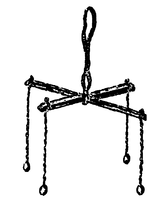
There is some evidence that, in addition to a marked cord, wooden rods were used by the Egyptians for distance measurement. The Egyptians had the groma, which was used to establish right angles. It was made of a horizontal wooden cross, pivoted at the middle and supported from above. A plumb bob was hung from the end of each of the four arms. A plumb bob is a shaped weight that hangs from a string. Because of the weight, the string will always be vertical. By sighting along each pair of plumb bob cords in turn, the right angle could be established. The device could be adjusted to a precise right angle by observing the same angle after turning the device approximately 90°. By shifting one of the cords to take up half the error, a perfect right angle would be obtained.


                                                                                             Egyptian groma

There is no record of any angle-measuring instruments of that time, but there was a level consisting of a vertical wooden A-frame with a plumb bob supported at the peak of the ‘A’ so that its cord hung past an indicator, or index, on the horizontal bar. The index could be properly placed by standing the device on two supports at approximately the same elevation, marking the position of the cord, reversing the ‘A’, and making a similar mark. Halfway between the two marks would be the correct place for the index.


                                                                                              A - frame

Thus, with their simple devices, the ancient Egyptians were able to measure land areas, replace property corners lost when the Nile covered the markers with silt during floods, and build the huge pyramids to exact dimensions. The Greeks used a form of log line for recording the distances run from point to point along the coast while making their slow voyages from the Indus to the Persian Gulf about 325 BC.

The Greeks introduced the astrolabe, which is an instrument to measure the altitude of stars above the horizon, in the 2nd century BC. It took the form of a graduated arc suspended from a hand-held cord. A pivoted pointer that moved over the graduations was pointed at the star. The instrument was not used for nautical surveying for several centuries, remaining a scientific aid only.

During their occupation of Egypt, the Romans acquired Egyptian surveying instruments, which they improved slightly and to which they added the water level and the plane table. About 15 BC, the Roman architect and engineer Vitruvius mounted a large wheel of known circumference in a small frame, in much the same fashion as the wheel is mounted on a wheelbarrow; when it was pushed along the ground by hand it automatically dropped a pebble into a container at each revolution, giving a measure of the distance travelled. It was, in effect, the first odometer.


                                                                                 Vitruviu's first odometer

The water level consisted of either a trough or a tube turned upward at the ends and filled with water. At each end there was a sight made of crossed horizontal and vertical slits. When these were lined up just above the water level, the sights determined a level line accurate enough to establish the grades of the Roman aqueducts. In laying out their great road system, the Romans are said to have used the plane table. It consists of a drawing board mounted on a tripod (a three legged stand (similar to that used by photographers) or other stable support.

It also consists of a straightedge ruler, usually with sights for accurate aim (the alidade) to the objects to be mapped, along which lines are drawn. It was the first device capable of recording or establishing angles. Later adaptations of the plane table had magnetic compasses attached. Arab traders brought the magnetic compass to the west in the 12th century AD. Plane tables were in use in Europe in the 16th century. Surveyors practiced the principle of graphic triangulation and intersection.


                                                                                            Plane table

In 1615 Willebrord Snell, a Dutch mathematician, measured an arc of meridian by instrumental triangulation. In 1620 the English mathematician Edmund Gunter developed a surveying chain, which was superseded only by the steel tape in the beginning of the 20th century. A surveyors chain consists of a series of links, each link about 0.2m long, used to measure distances accurately. Every 10 links (about 2m) has a small disc hanging from the chain, so that the position can be accurately measured.

                                                                                    Surveyors chain/Gunters chain

The study of astronomy resulted in the development of angle-reading devices that were based on arcs of large radii, making such instruments too large for field use. With the publication of logarithmic tables in 1620, portable angle measuring instruments came into use. They were called topographic instruments, or theodolites. They included pivoted arms for sighting and could be used for measuring both horizontal and vertical angles. Magnetic compasses may have been included on some. The vernier, an auxiliary scale permitting more accurate readings (1631), the micrometer microscope (1638), telescopic sights (1669) and spirit levels (about 1700) were all incorporated in theodolites by about 1720.

The development of the circle-dividing engine about 1775, a device for dividing a circle into degrees with great accuracy, brought one of the greatest advances in surveying methods, as it enabled angle measurements to be made with portable instruments far more accurately than had previously been possible.

By the late 18th century modern surveying can be said to have begun. One of the most notable early feats of surveyors was the measurement in the 1790s of the meridian from Barcelona, Spain, to Dunkirk, France, by two French engineers, Jean Delambre and Pierre Méchain. This was to establish the basic unit for the metric system of measurement. Many improvements and refinements have been incorporated in all the basic surveying instruments. These have resulted in increased accuracy and speed of operations and have opened up possibilities for improved methods in the field.

During the nineteenth century, the combination of a hot air balloon and a camera were used to produce maps and plans. It was difficult to survey large areas because the balloons were slow moving and a new photographic negative had to be loaded into the camera after each photograph was taken. In 1862 union soldiers used cameras mounted in hot air balloons to map behind the confederate lines.

It was not until the turn of the twentieth century, with the developments of the aircraft and invention of the roll of photographic film, that aerial photographs started to be used extensively within the survey industry. The first light wave Electronic Distance Measurement instrument was developed in 1943 to measure the velocity of light. Once the velocity of light was known, it was then possible to reverse the process so that a distance could be measured. In 1954, the light wave was replaced by a radio wave to increase the distance that could be measured. In the late 1960s, lasers were first used with EDMs.

In the mid to late 1970s, the United States of America sent their first Global Positioning System satellites into space. The final development was the extensive use of computers to perform most common data processing and recording of survey data.

Water Resources Engineering

Water is an essential ingredient for sustenance of life. The total quantity of water available on earth is estimated to be about 1400 million cubic kilometer, which is enough to cover the earth with a layer 3 km deep. However, 97.3% of this is saltwater in oceans, thereby leaving only 2.7% freshwater. Again, about 75% of the freshwater lies frozen in the Polar Regions and about 22.6% are groundwater- some of it very deep to be economically extractable. The surface freshwater is thus only about 0.007% of the total water occurring on earth. With increasing population, while the demand for water increases, anthropogenic pressures are rendering many water sources unfit for use because of the high level of pollution. Development and management of water resources is thus one of the important aspects of development at the present time. 

Water Resources Engineering is the science of designing, developing and managing projects and systems to protect and use water resources in a sustainable and efficient manner. This includes the design, construction and operation of water supply systems, flood control, water quality and water resources management. This engineering field is closely related to hydrology and the science of studying the properties of water and how it is distributed and used by humans. It can include the study of watersheds, rivers, lakes and coastal areas. 

Water Resources Engineering is a huge field which involves managing available water resources from the standpoint of both water quantity and water quality to meet the water needs of humanity and habitats at the local, regional, national or international level. It is the study and management of equipment, facilities and techniques that are used to manage and preserve life’s most plentiful resource - water. In addition to assessing how and the best ways to control water as it pertains to water-related activities – such as irrigation, waste disposal and canal development. Water resource engineers are also frequently involved in water management to ensure that it’s safe to drink both for humans, plants and animal usage. 

Managing water requires a sound understanding of water distribution systems such as rivers, canals, pipelines, culverts, ground water wells and water storage systems such as reservoirs, retention-detention ponds and aquifers. Water resources engineers must also have knowledge of various structures that are used to manage the conveyance of water such as sluice gates, emergency spillways and structures that are used to store water such as dams and dikes. In addition, water resources engineers must know techniques to assess future water demand as well as the quantity and quality of the available water resources in water bodies such as rivers, lakes and groundwater. Water resources engineers should also be familiar with the transport processes such as evaporation, transpiration, runoff and infiltration which are used by nature to move water globally.

History 

Water resources engineering has its roots in the ancient world, with evidence of its use in the Middle East, India and China since 3000 BC. Ancient civilizations used water engineering techniques to irrigate their agricultural land and store water for long-term use. In the middle ages, water engineering was used to build dams and canals for the purpose of flood control and agricultural irrigation. In the 16th and 17th centuries, water engineering began to be used for other purposes such as water supply and sewage systems, as well as providing a source of energy through the use of water wheels. In the 19th century, advances in engineering and technology have allowed engineers to design and build more complex water resource projects such as aqueducts and irrigation canals.

Water resources engineering has evolved over the past 9000 to 10,000 years as humans have developed the knowledge and techniques for building hydraulic structures to convey and store water. Early examples include irrigation networks built by the Egyptians and Mesopotamians and by the Hohokam in North America. The world’s oldest large dam was the Sadd-el-kafara dam built in Egypt between 2950 and 2690 B.C. The oldest known pressurized water distribution (approximately 2000 B.C.) was in the ancient city of Knossos on Crete. There are many examples of ancient water systems throughout the world.

The importance of water resources engineering includes the following: 

  1. It is essential to managing our water resources, helps to ensure the availability of clean drinking water, efficient use of water for agricultural purposes and protect our water sources. 
  2. It helps improve water quality to meet human and environmental needs. It can also help to reduce water pollution and to conserve water resources. 
  3. It is also important for infrastructure development and management of water systems. This includes the construction of dams, reservoirs, canals, pipelines and other water-related infrastructure. 
  4. It is essential for flood prevention and management, helps to identify possible areas of flooding, design and construction of dams and other flood control structures. 
  5. It is important for agricultural production and also helps develop irrigation systems, drainage systems and erosion control systems that improve crop yields and reduce the risk of crop loss due to drought and other environmental factors. 
  6. It is important for coastal zone management. They help to identify risk zones for coastal erosion and flooding and develop solutions to reduce these risks. 

Examples of water resources engineering projects include the following: 

  • Construction of artificial reservoirs 
  • Groundwater recharge 
  • Drip irrigation systems 
  • Desalination plants
  • Flood Control Systems

27 July 2023

Fluid Mechanics

Fluid mechanics is the branch of science that deals with the study of fluids (liquids and gases) in a state of rest or motion. Fluid mechanics is a science concerned with the response of fluids to forces exerted upon them. A fluid is a substance which deforms continuously under the application of a shear stress. The applications of fluid mechanics is enormous: breathing, blood flow, swimming, pumps, fans, turbines, airplanes, ships, rivers, windmills, pipes, missiles, icebergs, engines, filters, jets and sprinklers etc. It is an important subject of civil, mechanical and chemical engineering. 

From the point of view of fluid mechanics, all matter consists of only two states, fluid and solid. The difference between the two is perfectly obvious. The technical distinction lies with the reaction of the two to an applied shear or tangential stress. A solid can resist a shear stress by a static deflection; a fluid cannot. Any shear stress applied to a fluid, no matter how small, will result in motion of that fluid. The fluid moves and deforms continuously as long as the shear stress is applied. As a corollary, we can say that a fluid at rest must be in a state of zero shear stress.

Fluid

A substance that flows is called as fluid. All liquid and gaseous substances are considered to be fluids. Water, oil and others are very important in our day-to-day life as they are used for various applications. For instance water is used for generation of electricity in hydroelectric power plants and thermal power plants, water is also used as the coolant in nuclear power plants, oil is used for the lubrication of automobiles etc.

Whether the fluid is at rest or motion, it is subjected to different forces and different climatic conditions and it behaves in these conditions as per its physical properties. Its various branches are fluid statics, fluid kinematics and fluid dynamics. 

Fluid Statics 

The fluid which is in state of rest is called as static fluid and its study is called as fluid statics. 

Fluid Kinematics 

The fluid which is in state of motion is called as moving fluid. The study of moving fluid without considering the effect of external pressures is called as fluid kinematics. 

Fluid Dynamics 

The branch of science which studies the effect of all pressures including the external pressures on the moving fluid is called as fluid dynamics.

Liquid and Gases

A fixed amount of a liquid has a definite volume which varies only slightly with temperature and pressure. If the capacity of the containing vessel is greater than this definite volume, the liquid occupies only part of the container and it forms an interface separating it from its own vapour, the atmosphere or any other gas present.

A fixed amount of a gas, by itself in a closed container, will always expand until its volume equals that of the container. Only then can it be in equilibrium. In the analysis of the behaviour of fluids an important difference between liquids and gases is that, whereas under ordinary conditions liquids are so difficult to compress that they may for most purposes be regarded as incompressible, gases may be compressed much more readily. Where conditions are such that an amount of gas undergoes a negligible change of volume, its behaviour is similar to that of a liquid and it may then be regarded as incompressible. If, however, the change in volume is not negligible, the compressibility of the gas must be taken into account in examining its behaviour.

The continuum

An absolutely complete analysis of the behaviour of a fluid would have to account for the action of each individual molecule. In most engineering applications, however, interest centres on the average conditions of velocity, pressure, temperature, density and so on. Therefore, instead of the actual conglomeration of separate molecules, we regard the fluid as a continuum that is a continuous distribution of matter with no empty space. This assumption is normally justifiable because the number of molecules involved in the situation is so vast and the distances between them are so small. The assumption fails, when these conditions are not satisfied as, for example, in a gas at extremely low pressure.

Mechanics of Solids

Solid mechanics (also known as mechanics of solids) is the branch of Continuum Mechanics that studies the behavior of solid materials, especially their motion and deformation under the action of forces, temperature changes, phase changes and other external or internal agents. The application of the principles of mechanics to bulk matter is conventionally divided into the mechanics of fluids and the mechanics of solids. The entire subject is often called continuum mechanics.

Solid mechanics is also defined as a branch of applied mechanics that deals with behaviours of solid bodies subjected to various types of loadings. Solid mechanics is concerned with the stressing, deformation and failure of solid materials and structures.

The various bodies on which engineers are interested to apply laws of mechanics may be classified as Solids and Fluids.

Solids

The bodies which do not change their shape or size appreciably when the forces are applied are termed as solids. It can support normal forces.

Example: stone, steel, concrete etc.

Fluids

The bodies which change their shape or size appreciably even when small forces are applied are termed as fluids.

Example : water, gases etc.

History 

Solid mechanics developed in the outpouring of mathematical and physical studies by the Newton laws of motion. The need to understand and control the fracture of solids in structural member seems to have been a first motivation. Leonardo da Vinci sketched in his notebooks a possible test of the tensile strength of a wire. Galileo had investigated the breaking loads of rods under tension and concluded that the load was independent of length and proportional to the cross section area, this being a first step toward a concept of stress. He also investigated the breaking loads on beams that were suspended horizontally from a wall into which they were built.

Solid mechanics is usually subdivided into further two streams i.e Mechanics of rigid bodies or simply Mechanics and Mechanics of deformable solids

Rigid body 

Rigid bodies do not deform (stretch, compress or bend) when subjected to external loads. Rigid body is basically defined as a body where changes in the distance between any two of its points are negligible.

In actuality, no physical body is completely rigid, but most bodies deform so little that this deformation has a minimal impact on the analysis. For this reason, we usually assume that bodies in the statics and dynamics are rigid. 

Deformable body 

Deformable bodies deform (stretch, compress or bend) when subjected to external loads. Deformable body is basically defined as a body where changes in the distance between any two of its points could not be neglected.

26 July 2023

Urban Planning

Urban planning, also known as town planning, is a technical and political process that is focused on the development and design of land use and the built environment, including air, water and the infrastructure passing into and out of urban areas, such as transportation, communication and distribution networks and their accessibility. (Urban planning is similar to town planning but done on a much larger scale). Urban planning is the design and regulation of the uses of space that focus on the physical form, economic functions and social impacts of the urban environment. Urban planning concerns itself with both the development of open land and the revitalization of existing parts of the city, thereby involving goal setting, data collection and analysis, forecasting, design, strategic thinking and public consultation. Increasingly, the technology of geographic information systems (GIS) has been used to map the existing urban system and to project the consequences of changes. 

Urban planning is an interdisciplinary field that includes aspects of civil engineering, architecture, geography, political science, environmental studies, design science and other sciences. Practitioners of urban planning are concerned with research and analysis, strategic thinking, engineering architecture, urban design, public consultation, policy recommendations, implementation and management. 

The modern origins of urban planning lie in a social movement for urban reform that arose in the latter part of the 19th century as a reaction against the disorder of the industrial city. Many visionaries of the period sought an ideal city, yet practical considerations of adequate sanitation, movement of goods and people and provision of amenities also drove the desire for planning. Contemporary planners seek to balance the conflicting demands of social equity, economic growth, environmental sensitivity and aesthetic appeal. The result of the planning process may be a formal master plan for an entire city or metropolitan area, a project plan, or a set of policy alternatives. Successful implementation of a plan usually requires entrepreneurship and political astuteness. 

Traditionally, urban planning followed a top-down approach in planning the physical layout of human settlements. The primary concern was the public welfare, which included considerations of efficiency, sanitation, protection and use of the environment, as well as effects of the master plans on the social and economic activities. Over time, urban planning has adopted a focus on the social and environmental bottom-lines that focus on planning as a tool to improve the health and well-being of people while maintaining sustainability standards. Sustainable development was added as one of the main goals of all planning endeavors in the late 20th century when the detrimental economic and the environmental impacts of the previous models of planning had become apparent.

Urban

The concrete technical aspects defining ‘urban’ are: 

  • Population size 
  • Population density 
  • Economic base
  • Presence of a municipal body

There must be a minimum number of people residing in the place for it to be called urban; these people must be concentrated in a particular area and not scattered; there should be a minimum number of people in one unit area of land; they should be engaged in economic activities other than primary ones such as agriculture or animal rearing etc. and there must be a municipality or town committee or a planning and governing body to take care of the services and planning of that place. There is no common minimum number that can be put against these aspects, as no numbers are universally applicable all over the world. All countries have their own specifications for each of these aspects and they vary considerably.

In India, the Census defines an urban area as one with: 

  • Population more than 5000 
  • Population density over 400 persons per sq.km 
  • 75% of the male population engaged in non-agricultural occupations

Construction Engineering

Construction Engineering is a professional discipline that deals with the designing, planning, construction and management of infrastructures such as roads, tunnels, bridges, airports, railroads, facilities, buildings, dams, utilities and other projects. Construction engineering is similar to civil engineering, which also focuses on infrastructure design and development, but with more emphasis on managing the construction process on project sites. It is an important field because it ensures structures are safe, well-made and dependable. It also makes sure construction projects get finished by a set date and according to strict plans and building codes.

Construction engineers are involved in nearly every step of a construction project, from its design to its implementation. They manage building projects and maintenance, often being present to oversee workers and activities on-site. Projects and infrastructure that construction engineers might work on include:

  • Roads and highways
  • Bridges
  • Tunnels
  • Railroads
  • Housing projects
  • Airports
  • Energy sources like dams
  • Facilities such as wastewater treatment plants
  • Utilities
  • Drainage and sewage systems
  • Public buildings such as hospitals and sports stadiums

The typical duties of a construction engineer include:

  • Calculating the cost of inspections, testing, materials, equipment and labor to create a budget for each project
  • Managing funds appropriately to stay within budget
  • Using computer software and simulations to create project designs and 3D models
  • Performing risk analysis
  • Surveying potential construction sites and planning their layouts
  • Preparing bids from contractors and managing the contracting firms they hire
  • Choosing and acquiring materials and equipment
  • Hiring and overseeing workers and setting their schedules
  • Making sure projects follow environmental laws, government regulations and building codes
  • Designing and overseeing the construction of temporary structures needed on-site
  • Using engineering and business skills to solve any problems that might occur during construction
  • Staying up-to-date on the latest technology, building laws and construction processes 

Successful construction projects require a highly coordinated team effort. Builders and skilled trade’s people are required to lay brick, construct frames, install plumbing and electrical systems and ensure completion of a long list of other elements. With a large-scale construction project, construction engineers play an essential role in designing and implementing complicated building plans. They may also oversee the development or maintenance of critical infrastructure, ranging from roads and bridges to dams and water supplies.

25 July 2023

Environmental Engineering

Environmental Engineering is a branch of civil and chemical engineering that is concerned with natural resource management, the use of water, environmental pollution and human health. It is the study of problems associated with soil, air and water pollution. Environmental engineering is the development of processes and infrastructure for the supply of water, the disposal of waste and the control of pollution of all kinds. The aim is to protect public health by preventing disease transmission and to preserve the quality of the environment by averting the contamination and degradation of air, water and land resources. It was traditionally a specialized field within civil engineering and was called sanitary engineering until the mid-1960s and then the more accurate name Environmental Engineering was adopted.

As per ASCE, Environmental engineering is a profession that applies mathematics and science to utilize the properties of matter and sources of energy in the solution of problems of environmental sanitation. These include the provision of safe, palatable and ample public water supplies; the proper disposal of or recycle of wastewater and solid wastes; the adequate drainage of urban and rural areas for proper sanitation; and the control of water, soil and atmospheric pollution and the social and environmental impact of these solutions. Furthermore it is concerned with engineering problems in the field of public health, such as control of arthropod-borne diseases, the elimination of industrial health hazards, and the provision of adequate sanitation in urban, rural and recreational areas and the effect of technological advances on the environment. 

Projects in environmental engineering involve the treatment and distribution of drinking water, the collection, treatment and disposal of wastewater, the control of air pollution and noise pollution, municipal solid-waste management and hazardous-waste management, the cleanup of hazardous-waste sites and the preparation of environmental assessments, audits and impact studies. Mathematical modeling and computer analysis are widely used to evaluate and design the systems required for such tasks. Chemical and mechanical engineers may also be involved in the process. 

Environmental engineering applies scientific and engineering principles to improve and maintain the environment to protect human health, protect nature's beneficial ecosystems and improve environmental related enhancement of the quality of human life. Environmental engineers devise solutions for wastewater management, water and air pollution control, recycling, waste disposal and public health. This will design municipal water supply and industrial wastewater treatment systems and design plans to prevent waterborne diseases and improve sanitation in urban, rural and recreational areas. 

Environmental engineers study the effect of technological advances on the environment, addressing local and worldwide environmental issues such as acid rain, global warming, ozone depletion, water pollution and air pollution from automobile exhausts and industrial sources. An environmental engineer is responsible for improving the quality of the environment and public health and developing solutions to minimize the degradation of natural resources. They devise ways to control pollution, treat wastewater, distribute safe drinking water, manage hazardous waste, etc.

History

The earliest examples of environmental engineering date back thousands of years to when people moved away from a nomadic lifestyle and began living in semi-permanent settlements. This change required people to access clean water supplies and dispose of waste including sewage. As settlements grew and large-scale agriculture took hold, people also began to tackle challenges around air quality and soil contamination.

Evidence of environmental engineering can be seen from many different ancient civilizations around the world, including the Indus Valley Civilization, Mesopotamian Empire, Mohenjo Daro, Crete, Rome, Egypt and the Orkney Islands in Scotland. These civilizations included aqueducts, sewer systems, drinking water systems, irrigation systems and even public baths.

Despite these earliest examples of environmental engineering, nothing much changed in the field until the middle of the 19th Century, when Joseph Bazalgette was tasked with overseeing the construction of London’s first large-scale municipal sanitary sewer system following a series of cholera epidemics and the ‘great stink’ that was caused by the discharge of raw sewage into the river Thames. This "great stink," which was so noxious that it caused Parliament to evacuate Westminster, gave then-Prime Minister Benjamin Disraeli grounds to ask for 3.5 million pounds to improve the city's sewage disposal system.

Growing concerns over environmental degradation as well as air and water pollution in the middle of the 20th Century led to environmental engineering becoming its own academic discipline. These concerns were accentuated by new technologies such as pesticides like DDT that had detrimental effects on the environment. 

The goal of environmental engineering is to ensure that societal development and the use of water, land and air resources are sustainable. This goal is achieved by managing these resources so that environmental pollution and degradation is minimized. Environmental engineers study water, soil and air pollution problems and develop technical solutions needed to solve, attenuate or control these problems in a manner that is compatible with legislative, economic, social and political concerns. Civil engineers are particularly involved in such activities as water supply and sewerage, management of surface water and groundwater quality, remediation of contaminated sites and solid waste management. 

The activities of such engineers include, but are not limited to, the planning, design, construction and operation of water and wastewater treatment facilities in municipalities and industries, modeling and analysis of surface water and groundwater quality, design of soil and remediation systems, planning for the disposal and reuse of wastewaters and sludges and the collection, transport, processing, recovery and disposal of solid wastes according to accepted engineering practices.

Introduction to Transportation Engineering

Transport (British English) or transportation (American English) is the movement of people and goods from one place to another. The term is derived from the Latin words “trans” (across) and “portare” (to carry).

Transportation engineering is a sub-discipline of civil engineering which deals with the application of technology and scientific principles to the planning, functional design, operation and management of facilities for any mode of transportation in order to provide the safe, rapid, comfortable, convenient, economical and environmentally compatible movement of people and goods(transport). 

As per American Society of Civil Engineers (ASCE), there are six divisions related to transportation engineering i.e. Highway, Air Transportation, Pipeline, Waterway, Port, Aerospace, Coastal & Ocean and Urban Transportation. Transportation engineering is the planning, construction and operation of systems for moving goods and people by highway, rail, air, water and pipelines as well as urban and intermodal transportation.

From the beginning of history, human sensitivity has revealed an urge for mobility leading to a measure of Society's progress. The history of this mobility or transport is the history of civilization. For any country to develop with right momentum, modern and efficient transportation network has an important role. Mobility is a basic human need. From the times immemorial, everyone travels either for food or leisure. A closely associated need is the transport of raw materials to a manufacturing unit or finished goods for consumption. Transportation fulfills these basic needs of humanity. Transportation plays a major role in the development of the human civilization. For instance, one could easily observe the strong correlation between the evolution of human settlement and the proximity of transport facilities. Also, there is a strong correlation between the quality of transport facilities and standard of living, because of which society places a great expectation from transportation facilities.

In other words, the solution to transportation problems must be analytically based, economically sound, socially credible, environmentally sensitive, practically acceptable and sustainable. Alternatively, the transportation solution should be safe, rapid, comfortable, convenient, economical, and eco-friendly for both men and material. Transportation has always played an essential role in the development of society, originally with regard to trade routes and harbours, but more recently with regard to land- and air-based systems as well. It is the transportation engineer's responsibility to plan, design, build, operate and maintain these systems of transport, in such a way as to provide for the safe, efficient and convenient movement of people and goods.

The planning aspects of transport engineering relate to urban planning and involve technical forecasting decisions and political factors. Technical forecasting of passenger travel usually involves an urban transportation planning model, requiring the estimation of trip generation (how many trips for what purpose), trip distribution (destination choice, where is the traveler going), mode choice (what mode is being taken) and route assignment (which streets or routes are being used). More sophisticated forecasting can include other aspects of traveler decisions, including auto ownership, trip chaining (the decision to link individual trips together in a tour) and the choice of residential or business location (known as land use forecasting). Passenger trips are the focus of transport engineering because they often represent the peak of demand on any transportation system.

Transportation engineering primarily involves planning, design, construction, maintenance and operation of transportation facilities. The facilities support air, highway, railroad, pipeline, water and even space transportation. The design aspects of transport engineering include the sizing of transportation facilities (how many lanes or how much capacity the facility has), determining the materials and thickness used in pavement designing the geometry (vertical and horizontal alignment) of the roadway (or track). Beside these operations planning, logistics, network analysis, financing and policy analysis are also important to transportation engineering.

Before making any sort of planning, the engineer must take an account of the database of the area or if it is appropriate, the previous system in place. This inventory or database must include information on:

  • Population
  • Land use
  • Transportation facilities and services
  • Economic activity
  • Travel patterns and volumes
  • Regional financial resources
  • Community values and expectations
  • Laws and ordinances 

The transportation sector has undergone a sea change over the past few years, as more cities pilot smart city initiatives with Intelligent Transportation Systems (ITS). With ITS technologies, cities can gather and analyze data to design safer roads, cleaner vehicles and more efficient travel. New York City, for example, has installed cameras and sensors at over 10,000 traffic intersections to collect data and enact changes that improve safety and traffic flow. Professionals in transportation engineering careers play a pivotal role in the implementation of transportation advancements by combining technical knowledge and creative thinking skills.

Impact of Transportation

  • Economic development
  • Social development
  • Spatial development
  • Cultural development
  • Political development

24 July 2023

Introduction to Geotechnical Engineering

The term geo means earth or soil. This means it has something to do with the earth. Geotechnical engineering is an area of civil engineering that focuses on the engineering behaviour of earthen materials; or Geotechnical engineering, also known as geotechnics, is a discipline within civil engineering that focuses on the behavior of natural geological materials in engineered systems. It uses the principles of soil mechanics and rock mechanics for the solution of its respective engineering problems. It also relies on knowledge of geology, hydrology, geophysics and other related sciences. Geotechnical engineers recognize that soil and rock are the cheapest and most abundant building materials on earth, and consequently play a major role in the construction and performance of every type of civil engineering structure.

Geotechnical engineering is the study of the behaviour of soils under the influence of loading forces and soil-water interactions. This knowledge is applied to the design of foundations, retaining walls, earth dams, clay liners and geosynthetics. The goals of geotechnical engineers could range from the design of foundations and temporary excavation support, through route selection for railways and highways, to the increasingly important areas of landfill disposal of wastes and groundwater contamination. As such, the geotechnical engineer is involved in field and laboratory investigations to determine the engineering properties of site soils and other geomaterials and their subsequent use in the analytical study of the problem at hand.

As well as civil engineering, geotechnical engineering is also used in fields such as coastal engineering, offshore construction projects, mining, military and petroleum. While the fields of geotechnical engineering and engineering geology have overlapping areas of expertise, engineering geology is closely tied to geology while geotechnical engineering is aligned to civil engineering. Geotechnical engineers use their knowledge to determine the chemical, mechanical and physical properties of soil and rock for the design of earthworks, foundations and retaining structures. A site investigation of ground conditions is used to determine the depth of foundations, while earthworks may include embankments, channels, bunds and tunnels and retaining structures include retaining walls and earth-filled dams. Furthermore, if there are issues with the foundation, then the entire structure is in trouble. Therefore, geotechnical engineers play a critical role in every constructed project.

Until about the last 100 years geotechnical engineering was largely empirical and based on observation and careful reflection. Remarkable scientific advancement in this specialty within civil engineering has been achieved in the post-World War II era and continues today with the aid of high-performance computers, sensors, data visualization and advanced soil testing. Geotechnical engineering relies on the continuous application of engineering judgment. This judgment can be best developed by careful study of past successes and failures, and years of experience.

Every civil engineering structure and its construction is related to soil in some way, and subsequently, its design will depend on properties of the soil or rock. Geotechnical operations are of importance with respect to soil sampling, investigating geomaterial properties, controlling groundwater level and flow as well as environmental and hydrological interactions. Foundation engineering, excavations and supporting ground structures, underground structures, dams, natural or artificial fills, roads and airports, subgrades and ground structures, and slope stability assessments are examples of geotechnical engineering applications.

Despite notable progress in geotechnical engineering, many solutions are still approximate, which is mainly due to the non homogeneity of soils and dominant environmental conditions. Additionally, soils are more sensitive to local environmental conditions compared to other prefabricated building materials such as steel or concrete. Consequently, it would be necessary to have comprehensive understanding of natural soil deposits, environment interactions and response to local conditions to allow more accurate prediction of geomaterials engineering performance and behavior in projects.

20 July 2023

Introduction to Structural Analysis

A structure comprises several components that are connected to one another and function to transfer the loads to the soil successfully. The structure is a collection of elements linked together in such a way that serves a meaningful purpose. Thus, a structure is an arrangement and organization of interrelated elements in an object or system, with the load affecting structural components vertically or laterally. Different types of structures are concrete, framed, shell, membrane, truss, cables and arches, surface structure, etc. 

In other terms “structure” refers to a building or any other artificial object designed to support a load in construction. Structures can be made of various materials such as wood, steel, concrete or brick and can range from simple structures such as a shed or fences to complex structures such as bridges, skyscrapers or dams. 

Structural engineering is the field of engineering that deals with the design, analysis and construction of structures. A properly designed and constructed structure must resist various forces and loads such as gravity, wind, earthquakes and other external factors to ensure the safety of the structure.

Structural analysis is the prediction of the performance of a given structure under prescribed loads and/or other external effects, such as support movements and temperature changes. The performance characteristics commonly used in the design of structures are

  1. Stress or stress resultant, such as axial force, shear force and bending moment
  2. Deflection
  3. Support reaction

Thus, the analysis of a structure usually involves determination of these quantities as caused by a given loading condition. 

History of Structural Engineering

Since the dawn of history, structural engineering has been an essential part of human endeavor. However, it was not until about the middle of the seventeenth century that, engineers began applying the knowledge of mechanics (mathematics and science) in designing structures. Earlier engineering structures were designed by trial and error and by using rules of thumb based on past experience. The fact that some of the magnificent structures from earlier eras, such as Egyptian pyramids (about 3000 BC), Greek temples (500–200 BC), Roman coliseums and aqueducts (200 BC–AD 200), and Gothic cathedrals (AD 1000–1500), still stand today is a testimonial to the ingenuity of their builders.

Galileo Galilei (1564–1642) is generally considered to be the originator of the theory of structures. In his book entitled ‘Two New Sciences’, which was published in 1638, Galileo analyzed the failure of some simple structures, including cantilever beams. Although Galileo’s predictions of strengths of beams were only approximate, his work laid the foundation for future developments in the theory of structures and ushered in a new era of structural engineering, in which the analytical principles of mechanics and strength of materials would have a major influence on the design of structures.

Following Galileo’s pioneering work, the knowledge of structural mechanics advanced at a rapid pace in the second half of the seventeenth century and into the eighteenth century. Among the notable investigators of that period were Robert Hooke (1635–1703), who developed the law of linear relationships between the force and deformation of materials (Hooke’s law); Sir Isaac Newton (1642–1727), who formulated the laws of motion and developed calculus; John Bernoulli (1667–1748), who formulated the principle of virtual work; Leonhard Euler (1707–1783), who developed the theory of buckling of columns; and C. A. de Coulomb (1736–1806), who presented the analysis of bending of elastic beams. In 1826 L. M. Navier (1785–1836) published a treatise on elastic behavior of structures, which is considered to be the first textbook on the modern theory of strength of materials.

The development of structural mechanics continued at a tremendous pace throughout the rest of the nineteenth century and into the first half of the twentieth, when most of the classical methods for the analysis of structures described in this text were developed. The important contributors of this period included B. P. Clapeyron (1799–1864), who formulated the three-moment equation for the analysis of continuous beams; J. C. Maxwell (1831–1879), who presented the method of consistent deformations and the law of reciprocal deflections; Otto Mohr (1835–1918), who developed the conjugate-beam method for calculation of deflections and Mohr’s circles of stress and strain; Alberto Castigliano (1847–1884), who formulated the theorem of least work; C. E. Greene (1842–1903), who developed the moment-area method; H. Muller-Breslau (1851–1925), who presented a principle for constructing influence lines; G. A. Maney (1888–1947), who developed the slope-deflection method, which is considered to be the precursor of the matrix stiffness method; and Hardy Cross (1885–1959), who developed the moment-distribution method in 1924.

The moment-distribution method provided engineers with a simple iterative procedure for analyzing highly statically indeterminate structures. This method, which was the most widely used by structural engineers during the period from about 1930 to 1970, contributed significantly to their understanding of the behavior of statically indeterminate frames. Many structures designed during that period, such as high-rise buildings, would not have been possible without the availability of the moment-distribution method. The availability of computers in the 1950s revolutionized structural analysis. Because the computer could solve large systems of simultaneous equations, analyses that took days and sometimes weeks in the precomputer era could now be performed in seconds.